Caribbean Atlantic Margin Deep Imaging (CAMDI)
06 November 2018MultiClient Geophysical AS (MCG) is currently acquiring the Caribbean Atlantic Margin Deep Imaging seismic survey. This survey will consist of 16,367 km MC2D seismic data targeting the highly prospective and underexplored basin along the Southeastern Caribbean and Western Atlantic Margin of Northeast South America. High quality pre-stack time, pre-stack depth, gravity and magnetic data will be made available late 2018, early 2019 prior to the license rounds in Barbados and Trinidad and Tobago.
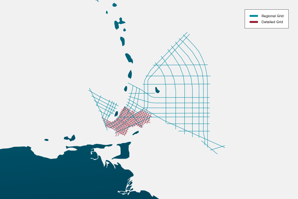
The Caribbean Atlantic Margin Deep Imaging survey is designed in two grids. The Regional Grid is designed to assist oil companies to better understand the regional tectonic framework of the various basins along the Southeastern Caribbean and Western Atlantic Margin of Northeast South America. The Detailed Grid, off Trinidad and Grenada, will enable companies to outline potential prospects and tying the producing areas in Trinidad and Tobago to the underexplored deeper part of the Tobago Trough. (See Figure 1)

The Tobago Trough is an underexplored area flanked by oil and gas production to the East and South in Barbados and Trinidad and Tobago, and recently the new gas discovery offshore Grenada. Based on seismic interpretation of the 2013 MCG MC2D survey in Barbados, a thick sedimentary succession can be observed in the Tobago Trough. The oil prone La Luna age equivalent source rock is expected to be present in this area and multiple large prospects have already been identified. Prospects expected to be sourced from the La Luna formation. (See Figure 2). Onshore oil production in Barbados has existed since the beginning of the previous century supporting the Cretaceous La Luna age equivalent source rock connection. This onshore oil production comes from the reservoirs of Eocene sandstones from the Scotland Group and the sweet, light crude oil is geochemically proven to be generated from the La Luna equivalent source rocks.
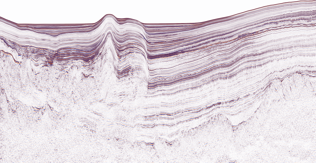
Figure 2. Regional line showing the deeper data in the Tobago Forearc Basin where mapping of the source rock should be possible.
Geological factors and possibilities
All the components for successful exploration are present offshore in the Greater Tobago Trough. Based on the 2013 MCG 2D seismic survey offshore Barbados, basin modelling of the La Luna formation, suggests the presence of source rock within the oil window. Good sandy reservoirs, likely originating from the Paleo-Orinoco delta can be tied into the new seismic data. Structural and stratigraphic traps have been mapped out and Direct Hydrocarbon Indicators (DHI’s) can be observed in connection with many of these traps. The area covered by the new seismic survey is underexplored and poorly understood due to lack of regional deep data. The Tobago Trough has only been tested along the margin in Trinidad and Tobago. The deeper oil plays are still to be explored in an area soon to be available for exploration.
Regional geology and large prospects
During the breakup of the supercontinent Pangea, Barbados was geographically located in the Southeast corner of the open North Atlantic Basin prior to the opening of the South Atlantic. The area is close to the Orinoco Delta and Trinidad. This region was located in the Southeast corner of the opening of a large seaway that extended to the Gulf of Mexico in the Middle Jurassic (roughly 166 million years ago). A late Tertiary collision between plate boundaries around the Caribbean Plate and the Atlantic Plate created a large accretionary ridge which sets up the current geology of the region.
Large structures and prospects can be found in many locations. Examples of some of the large-scale leads from the Tobago Fore-arc Basin and Tobago Trough can be seen in Figure 3 and Figure 4.
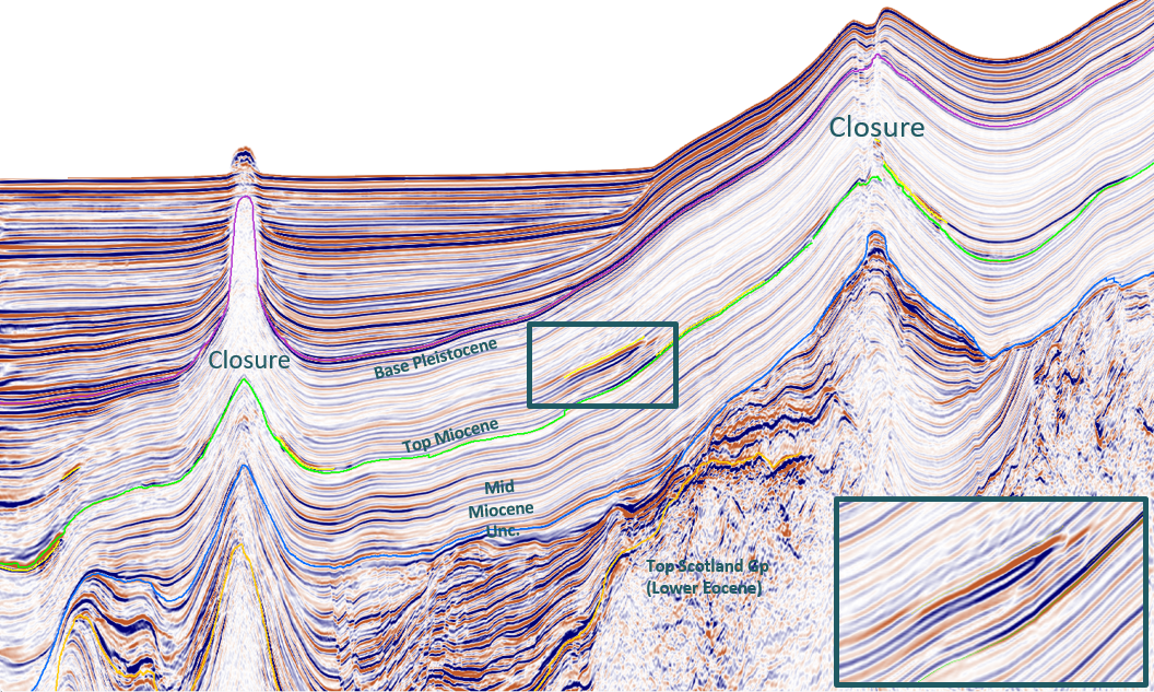
Figure 3. Examples of large structures and leads in the Tobago Forearc Basin with potential Direct Hydrocarbon Indicators.
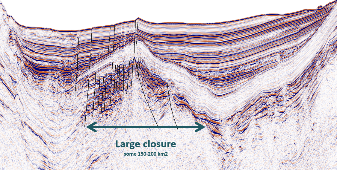
Figure 4. Large structure in the Barbados Trough.
Summary of the Greater Tobago Trough offshore opportunity
The Greater Tobago Trough area is an excellent exploration opportunity and only a few exploration wells are drilled in this vast virgin area. Several world class leads have been identified with the new MCG seismic data. Information from the oil field onshore Barbados provides insight to the potential in the large structures offshore. The presence of good reservoirs in the offshore, along with favorable terms from the Governments have created an exploration environment that is worth exploring. Deep water license rounds are expected to be announced in Barbados and Trinidad and Tobago during 2019.
All seismic images originates from https://www.offshore-mag.com/articles/print/volume-75/issue-4/geology-geophysics1/barbados-invites-bids-for-offshore-blocks.html
This article is also published on AAPG Explorer Online, November 2018: https://explorer.aapg.org/story/articleid/49829/new-exploration-opportunities-in-the-southeastern-caribbean
Contact us today for more information
Lars Ivar Leivestad
lars.ivar.leivestad@mcg.no
NO: (+47) 977 14 997