Mozambique Angoche MC3D
04 April 2022Geoex MCG is pleased to present the multi-client 3D project in Mozambique, covering up to 8,500 km2. The proposed survey will be designed to cater to clients’ interest, with a priority considered in the North Angoche Basin, and further possibilities in other areas of Angoche, Zambezi and Save Basins.
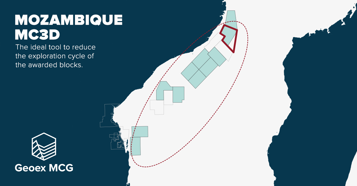
The pre-qualifying stage of the Mozambique 6th Licensing Round is now complete and offers the ideal ground for this multi-client 3D opportunity. The 3D data will be the ideal tool for reducing the exploration cycle for the awarded blocks.
Please contact us to discuss your interest to participate in this project:
Jean-Philippe Rossi
Executive VP
E: jp.rossi@geoexmcg.com
T: +44 7729 107 409
Timeline
The shorter exploration cycle is a natural choice to support your Licensing Round application strategy.
- Environmental Impact Assessment taking place during the Licensing Round
- Broadband 3D acquisition Q4 2022
- First QC’d data available Q1 2023
- Pre-Stack Depth Migration completed by Q3 2023
G&G and Objectives
Angoche Prospectivity
Geoex MCG has agreed with the Instituto Nacional de Petróleo (INP) to shoot a modern high-resolution 3D dataset on the A6-B block offshore Mozambique which will cover an area up to 8,500km2, currently available in the ongoing 6th Licensing round.
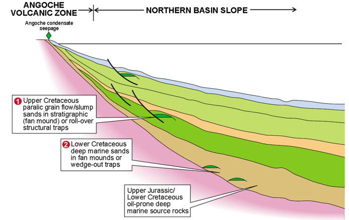
This 3D survey will further elucidate the potential prospectivity of the very underexplored Angoche margin. The offshore Angoche area contains sediment deposited in a rift, rift-sag, drift, and passive margin environment. Prospectivity of the Angoche margin is supported by discoveries in the Rovuma basin to the north and the onshore Pande and Temane fields in the south. These discoveries indicate a working petroleum system that may extend to the Angoche margin.
It is envisaged that oil-prone deep marine source rocks (TOC ~8%) in the Upper Jurassic/Lower Cretaceous (Lower Domo shale equivalent) charge the overlying Lower Cretaceous deep marine sands (Pemba Fm) in fan mounds or wedge out traps on the Northern Basin Slope. Further possible prospectivity lies in the Upper Cretaceous (Domo Sand/Lower Grudja equivalent) which hosts the Rovuma gas discoveries with ~5TCF in total. In the Angoche margin, these reservoirs are paralic grain flow/slump sands in stratigraphic (fan mound) or roll over structural traps. There is also potential prospectivity envisaged close to the Davie fracture zone in a more distal play.
The acquisition parameters, therefore, target these reservoir features to allow interpreters further insights that are currently unavailable. Furthermore, by utilising long streamers, the crustal regime of the Angoche margin will be imaged to a high standard which has important implications for the thermal regimes. Further parameters include a 2ms sampling rate and an 11-second recording length.
This dataset is perfect for those interested in the A6-B block.
Survey Parameters
Open to client input and specification
Parameter | Value |
Full Fold Surface Area | 8,550 km2 (Phase 1) |
Acquisition Type | Broadband Acquisition |
Number of Streamers | 10 |
Streamer Length | 8,000 m |
Streamer Separation | 150 m |
Streamer Depth | 12 m |
Recording Length | Continuous (min. 11 s) |
Sampling | 2 ms |
Shot Point Interval | 50 m (for the same source) |
Number of Sources | 3 |
Source Depth | 8-9 m |
Source Characteristics | 3,020 in3 ~106 bar m |
Bin Size | 6.25 x 25 m |
Nominal Fold | 100 |