The Caribbean Atlantic Margin Deep Imaging (CAMDI)
05 October 2020

Geoex MCG are pleased to present the Caribbean Atlantic Margin Deep Imaging (CAMDI) survey.
This 16,348 km survey is targeting the highly prospective and underexplored basin along the Southeastern Caribbean and Western Atlantic margin of Northeast South America.
The Caribbean Atlantic Margin Deep Imaging survey is designed to assist oil companies to better understand the regional tectonic framework of the various basins along the Southeastern Caribbean and Western Atlantic margin of Northeast South America. The survey includes a Detailed Grid, off Trinidad and Tobago and Grenada, to provide more detail, tying the producing areas to the underexplored deeper part of the Tobago Trough.
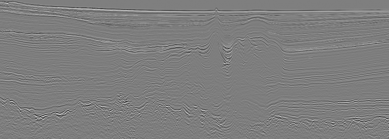
The Tobago Trough is an underexplored area flanked by oil and gas production to the East and South in Barbados and Trinidad and Tobago and recently, with a new gas discovery offshore Grenada.
Seismic interpretation of this survey along with the 2013 Geoex MCG 2D survey in Barbados, shows a thick sedimentary succession in the Tobago Trough. The presence of a mature La Luna oil prone source rock in the Trough seem likely.
The Caribbean Atlantic Margin Deep Imaging survey ties the Sandy Lane well in Barbados in addition to several deeper wells in Trinidad and Tobago.
Data has been processed in both time and depth, utilizing the latest broadband technology. Gravity and Magnetic data were also acquired with the survey.
The Caribbean Atlantic Margin Deep Imaging survey was acquired using a 37.5 meter shotpoint interval and Continuous recording 18 second record length. The survey covers Barbados, Trinidad and Tobago, Grenada and St. Vincent.
The surveys are well positioned for upcoming License rounds in the region.
Read the technical paper here.
Survey Acquisition Parameters
Concept | Parameter |
Acquisition system | Sercel Seal System |
Shotpoint interval | 37.5 m |
Sample rate | 2 ms |
Cable type | Sentinel Solid Streamer |
Number of receivers | 960 |
Receiver interval | 12.5 m |
Cable length | 12 km |
Cable depth | 12 m (+/-1 m) |
Fold | 160 |
Recording time | 18 s (Continuous Recording) |
Overlap | TBD |
Recording mode | Continuous Recording |
Receiver type | Solid: Sercel Flexible Hydrophone |
Source type | G-GUN |
Source volume | 5,020 in2 |
Number of sources | 1 |
Pressure | 2,000 psi |
Source depth | 7.5 (+/- 1 m) |
Filter | 3 HZ analogic-Filter antialias linear |
Data format | 8058 IEE |
X min | 150 m |
X max | 12,200 m |
Gravity | Yes |
Magnetic | Yes |
Contact us today for more information:
Robert Sorley
robert.sorley@geoexmcg.com
+1 (281) 744 0854